Landform Sediment Assemblage (LfSA)
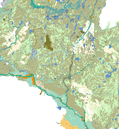
Landform Sediment Assemblage (LfSA) map
MnModel is the first archaeological predictive modeling project to develop models assessing the potential for finding archaeological sites both at the soil surface and at different depths.
Minnesota has a number of sedementary environments, including large floodplains, extensive peatlands, areas of windblown sediment, and smaller features such as alluvial fans and colluvial slopes, yet few deeply buried sites have been found. With a large number of bridge replacement projects underway, MnDOT needed a means of determining where to survey for deeply buried archaeological sites. Buried sites were such a minute part of the MnModel archaeological database that we must consider the statistically derived models to be predictors only of surface archaeological sites. Anticipating potential for deeply buried archaeological sites required a different approach.
Mapping Landform Sediment Assemblages
The MnModel project, in Phases 1 through 3, included 1:24,000 scale mapping of landform sediment assemblages (LfSAs) for seven major river valleys, a portion of the Red Lake Bog, a portion of the Lake Agassiz Basin, and portions of five distinct upland areas. Mapping considered both surface and subsurface characteristics of landscape features. Since then the Anoka Sand Plain, the Zumbro River, and remaining stretches of the Mississippi River have been mapped.
Landscape Suitability Models
Landform sediment assemblage data were used to develop Landscape Suitability Models. These models characterize the potential for the preservation of archaeological sites at the surface and at three subsurface levels (0-1 meters, 1-2 meters, and 2-5 meters). Potential is based on age (is the sediment or surface old enough, but not too old) and depositional environment (was the environment sufficiently low energy to have preserved archaeological resources in situ). MnDOT's protocol for testing for deeply buried archaeological sites is based on the use of the landscape suitability models.