Preparing and maintaining core GIS and CAD data at a planning level scale
Collection Methods
General Map Update Methods
The GIM unit keeps an updated record of roadway systems throughout Minnesota and corporate data for every municipality in the state. The GIM unit sends a request for information in the form of digital maps to all counties and municipalities every year. Each county or city representative outlines any changes in the previous year, and returns the legal descriptions and map to the GIM unit. Minnesota statute orders that certain adjustments, such as MnDOT commissioner's orders, turnback resolutions, and municipal boundary adjustments require further proof and documentation before becoming official. Once a change is confirmed through the proper channels, the GIM staff updates the map.
History
In the late 1980's, MnDOT studied GIS technology for developing its own needs and services. In 1992, internal task forces and Management Information Center (LMIC) worked together to incorporate CAD digitizing efforts into a statewide seamless basic core of geography. This would provide a way for relating MnDOT spatial data to other spatial data. MnDOT chose Environmental System Research Institute's (ESRI) Arc/Info. CAD digitizing continued, but at an accelerated pace in order to complete statewide at a 1:24,000 scale coverage in State Plane Coordinates (NAD 83) projection within 18 months.
In March 1993, the MnDOT Cartographic Unit converted and updated the digitized one-third of statewide quad coverage, and accelerated digitizing the state's remaining quad coverage. By the end of 1994, employees finished digitizing, and work began creating Arc/Info GIS coverages from the CAD line work, also switching the projection formats to Universal Transverse Mercator (UTM) Minnesota extended Zone 15 (NAD 83). In 1996, MnDOT produced its first State of Minnesota GIS BaseMap on CD-ROM. While the BaseMap files did not contain attribution for all of its 21 data layers, it fulfilled MnDOT's initial goal to display MnDOT geospatial information. BaseMap 2000: several employees determined to capture the alignment of all local city streets built since the release of the original BaseMap and designate Municipal State Aid Streets (MSAS), County Roads (CR), railroads, civil townships, and selected state/federal agency administrative boundaries (forests, parks, etc.).
MnDOT provides annual updates to the BaseMap. The Minnesota Trunk Highway (TH) and County State Aid System (CSAH) alignment and route coverages as well as municipal boundary coverage are improved each year. Changes to roads come from several sources including county engineers, city engineers, the MnDOT State Aid office (who manage county state aid highways and municipal state aid streets), the most recent aerial photos available, and construction plans.
Map Products
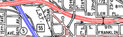
The Geographic Information & Mapping (GIM) Unit generates several map products for the State of Minnesota. The most popular is the Official State Highway Map, which is produced every two years. The unit also creates and maintains maps for all of Minnesota’s 87 counties and 856 cities, over 1,700 townships, as well as producing a unique series of 56 maps covering the Twin Cities metro area, called the Metropolitan Area Street Series. GIM will produce more Street Series maps for other highly populated areas in Minnesota.
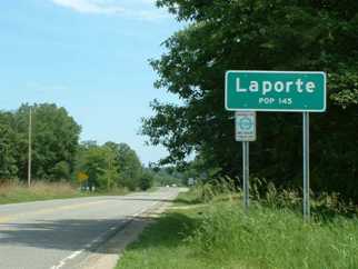
Sign on the side of Hubbard County Highway 39 marking the corporate boundary of Laporte
The GIM Unit produces maps which contain a number of recognizable features such as roads, bridges, legislative boundaries, water attributes, public facilities, and text annotation, with an emphasis on roadway systems and corporate data. Roadway systems include major or minor highways, roads, streets, and railroads. Corporate data are the municipal (city) boundaries that depict the exact border between two cities or a city and a county. For visual reference, some features are not included at specific map scales.
Official State Highway Map
The Official State Highway Map displays the major features of the transportation system in Minnesota-- major roads and corresponding route systems. The map also shows state and county legislative boundaries, major cities, unincorporated places, state and national parks, major railroads, airports, and other features. Corporate limit changes that affect cities with populations over 25,000 also appear. The State Highway Map is the only map showing the city-to-city mileage chart, the city finder index, and various points of interest throughout the state. MnDOT releases the product every two years (on odd years) and is available in both paper and digital formats. See the information below:
For a free paper copy, email the Explore Minnesota Tourism Office at explore@state.mn.us or call them at 1-888-TOURISM (868-7476)
The GIM Unit updates County Maps every year, with information received from each county in Minnesota. The maps data for highway planning throughout the state. Map scales vary due to the difference in county size, with a common scale of 1 inch = about 0.5 mile. Maps display higher route systems first (Interstates, US Highways, Minnesota Highways, County State Aid systems) when all roads cannot be shown within a county.
Municipality (City) Maps
Municipality (City) Maps show the state transportation system with detail at city-level. These maps show all route systems, including all city streets and private roads, with yearly updates. Map scales may vary due to the difference in city size, with a common scale of 1 inch = about 1/6 to 1 mile.
Cities over 5,000 in population qualify for funding from the Municipal State Aid System (MSAS) while municipalities under 5,000 do not qualify. All cities will have their own maps.
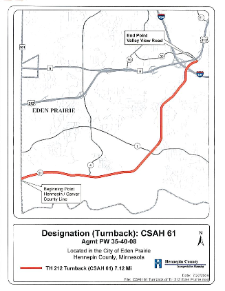
The GIM Unit uses turnback resolutions when making edits to their map products
Township Maps
Township Maps show the state transportation system within each county. These maps show more detail with township roads and private roads, including unincorporated communities. Most township maps will have a common scale of 1 inch = 1600’ (about 1/6 to 1 mile.) All townships will have their own maps.
Metro Street Series
The Metro Street Series 56 individual maps (with a reference grid map inset) covering the seven-county metro area and part of the surrounding area. GIM updates the Street Series annually and produces the maps at a detailed scale of 1 inch = about 1/4 mile. MnDOT and other agencies use these special scale maps for planning and reference purposes.
The major elements on each map include all road systems, municipal boundaries, and water features.
The GIM unit maintains a complete file of all annexation documents we receive. The public and other agencies can use these documents, which are located in the Office of Transportation System Management on Third Floor North of MnDOT’s Central Office.
Please visit the Municipal Boundary Adjustment Unit website at https://www.mba.state.mn.us/ for municipal boundary digital changes.
Updating the GIM Unit’s many map products requires a team effort. This thorough and ongoing process depends on the unit’s careful work tracking trunk highway projects, staying updated on state aid funding changes, and checking feature locations using aerial photography. MnDOT district offices, other state departments, and local governments sharing their feedback is also very important. The combination of MnDOT’s proactive measures and other organizations and government offices support, allows the GIM Unit to produce the most accurate map product possible.