About this study


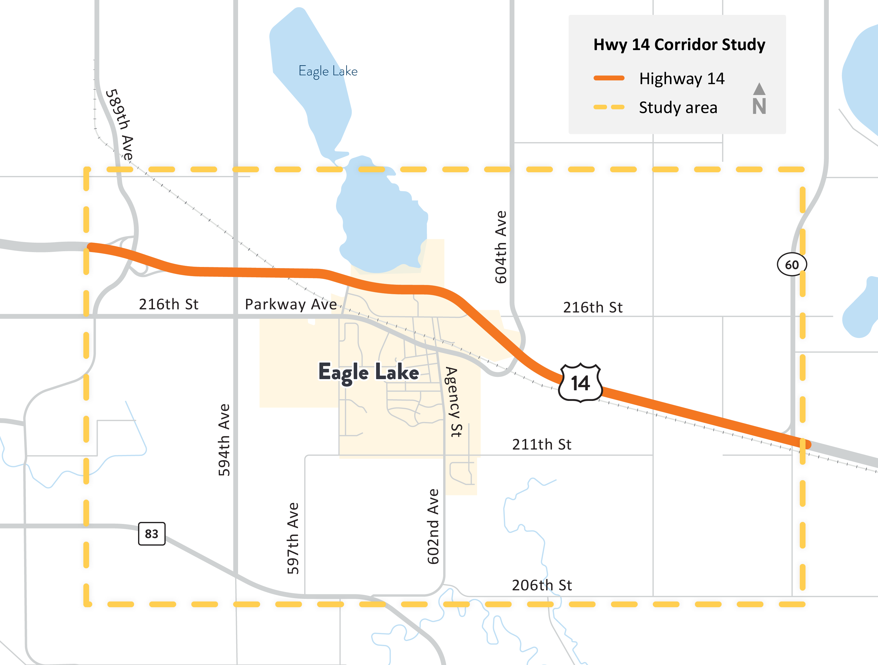
Hwy 14 Eagle Lake Corridor Study area. View full-size map.
The Mankato Area Planning Organization (MAPO) is partnering with MnDOT and local communities to study and plan for the future of Hwy 14 in the Eagle Lake area.
The portion of the highway between County Road 12 and Hwy 60 currently experiences various safety and mobility issues. This study will look at opportunities for future improvements to address these issues, while also incorporating the community's goals and needs.
Study goals
Define a long-term transportation system vision for Hwy 14 that ensures safety, mobility, economic vitality, resiliency, and access for all modes of travel.
Secure public and agency support for the system vision where community input and needs are meaningfully incorporated into the recommended vision and the study recommendations are adopted by applicable agencies.
Develop a detailed, feasible implementation plan outlining future improvements, sequencing and triggers, timing, cost, and agency responsibility.
Opportunities for public input
Public input is an integral part of the Hwy 14 Eagle Lake study. From Summer 2024 through Summer 2025, the public had opportunities to provide feedback on the study area, community priorities, and roadway concepts. Comment about the final recommendations can be submitted via email on the Contacts tab.
Phase 2 Engagement Summary (Spring 2025)
The second public engagement phase focused on gathering feedback from the public on potential future concepts and how well each concept met their needs. Input from the community was received through the following:
- Totcho Night Tator Days Fundraiser on March 28, 2025
- Mankato HyVee on April 6, 2025
- Mankato Travel Center on April 14, 2025
- Public meeting at the Eagle Lake American Legion on April 8, 2025
- Online survey through the project’s Social Pinpoint site (now closed)
The four alternatives considered in Phase 2:
Concept A
Concept B
Concept C
Concept D
Phase 1 Engagement Summary (Summer 2024)
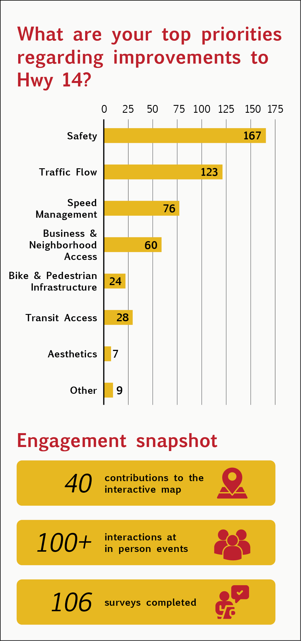
The first public engagement phase focused on gathering user experiences along and across Highway 14 in Eagle Lake. The community was engaged at the Tator Days Pancake Breakfast on July 20, 2024, at a public meeting at the Eagle Lake City Hall on July 29, 2024, and through an interactive map and survey on the project website.
Key Takeaways

Phase 1 Engagement Summary
- Desire for improved safety along Highway 14
- Concern about safely using J-turns
- Concerns about visibility at some intersections making it difficult to enter and exit Highway 14
- Challenging to cross multiple lanes of traffic after entering Highway 14 from J-turns
- Some residents actively avoid driving on Highway 14 due to feeling unsafe
- Desire for better traffic flow
- Desire for acceleration and deceleration lanes at J-turns to allow drivers to more easily enter and exit Highway 14
- Concerns about traffic backups in the morning and evening on side roads
- Desire for more speed management
- Some find it challenging to enter Highway 14 due to high speeds
- Concerns with business and neighborhood access
- Frustration with access being reduced to local businesses and surrounding neighborhoods
- Desire to explore acceleration and deceleration lanes to better interact with traffic flow
