Our document management platform is undergoing planned maintenance between 3:00pm and 7pm on Wednesday, October 23. We apologize for any inconvenience and appreciate your understanding.

Minnesota Department of Transportation

511 Travel Info

Highway 3/South Robert Street

West St. Paul

You're invited to join us at an in-person public meeting on Tue, Nov. 19 to learn about the recommended ideas for improvement for South Robert St. and share feedback. For more information, visit the meetings webpage.

About this study

Highway 3/Robert Street from Mendota Road to Annapolis Street in West St. Paul study location map

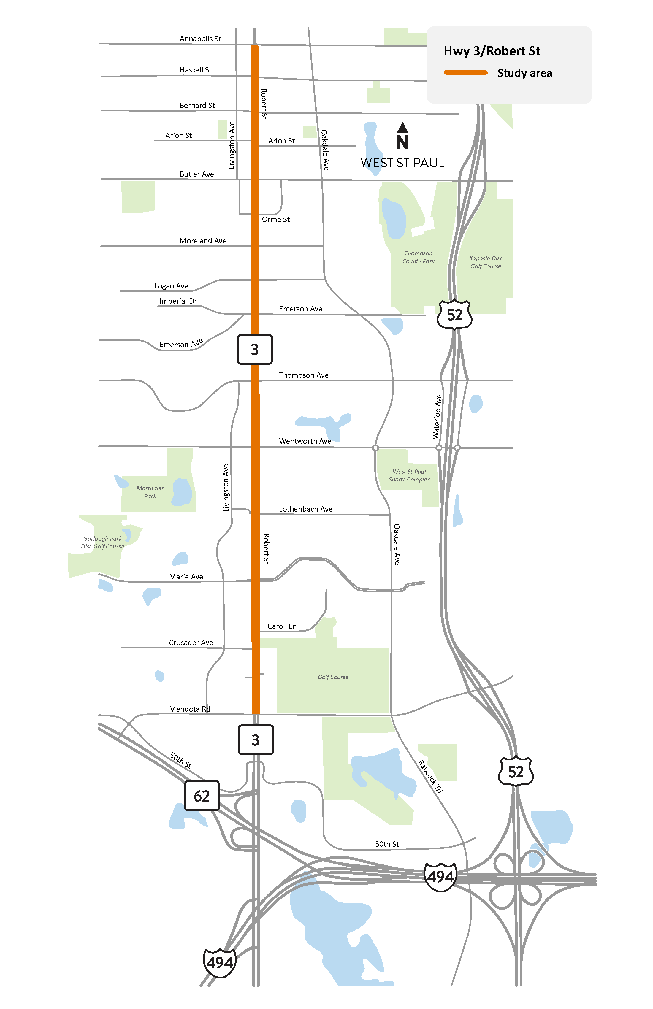
South Robert St. in West St. Paul study area map

View full-size map

We are studying Hwy 3/South Robert St. between Mendota Rd. and Annapolis St. in West St. Paul to identify possible improvements to safety and connectivity for people who walk, bike, ride transit and drive.

This section of South Robert St. was reconstructed in 2015-2016 to improve transportation mobility, access management and safety. The reconstruction added a center median to restrict hazardous left turns, consolidated driveways along the road to simplify access and installed new traffic signals, streetlights and landscaping. Despite those improvements, the section of roadway has seen continued safety concerns for users since completion of the reconstruction project.

This study will coordinate with Metro Transit to prepare the area for the G Line arterial Bus Rapid Transit service, which will include new on-street transit stations in the study area.

We will gather input from communities close to the study area through engagement. Sign up for email updates to receive information on how you can share your input and stay up to date on this study.

We are also conducting community engagement for an upcoming nearby project on Robert St. between 12th St. in downtown St. Paul and Annapolis St. in West St. Paul. For more information, visit the project webpage.

Summary of work

  • Assess and report on existing conditions
  • Ask people to share their transportation experiences and needs
  • Develop and recommend ideas for improvement
  • Coordinate with the planning, design and construction of Metro Transit’s G Line arterial Bus Rapid Transit service

Study update

September 2024

Engagement summary

In May and June of 2024, the study team conducted the first of two engagement phases to inform the public about the study and get feedback from community members who travel along and across Hwy 3/South Robert St. The study team attended two pop-up events, including West St. Paul’s WestFest, and hosted an in-person public meeting. There was also an online comment map available.

Infographic showing a list of information about the in-person public meeting. List includes 27 attendees, 15 comment cards submitted and 12 comments on tabletop map
Infographic showing that there were 61 comments from 27 people on the online comment map and that the study team spoke to 115 people at 2 pop-up events

Themes from the public engagement process include:

  • Speeding
  • Expand and improve connectivity and safety for people walking and biking
  • Dangerous left turns
  • Need for improved transit amenities
  • Sightline concerns

Existing conditions review summary

An existing conditions review was completed using available data, observations from a study area field review that was completed in March 2024 and public input.

Through evaluation of existing conditions, the following key findings were identified:

Road geometry and condition
  • The South Robert St. study area consists of two through lanes in each direction, separated by a center median. Sidewalk is present on both sides and the roadway is continuously lit. Transit stops are located at various intersection corners.
  • Pavement on and sidewalk along South Robert St. appears to be in good condition. Our most recent assessments of pavement and pedestrian infrastructure along the road also reflect this.
  • The topography of South Robert St. is hilly; with grades being steepest just south of Lothenbach Ave. (5.7% downhill in the northbound direction), on either side of Emerson Ave. intersection (3.8% uphill in the northbound direction), and north of Bernard St. (4.2% downhill in the northbound direction).
Safety

Crash rates (CR) represent the number of total crashes per million vehicles entering the intersection or road segment during the study period. Fatal and serious injury crash rates (FAR) are crash rates computed using only fatal and severe injury crashes. Critical crash rates (CR) and critical fatal and serious injury crash rates (FAR) are both rates which have been statistically adjusted based on other roads with similar characteristics to remove elements of chance and randomness. For both intersections and segments, a crash rate (CR or FAR) higher than the critical crash rate (CR or FAR) indicates a safety concern at that intersection.

  • Segment crash rates (based on year 2018 to 2022 crash data) all exceed the critical crash rate. All segments but Wentworth Ave. to Marie Ave. and Marie Ave. to Mendota Rd. had a fatal and serious injury crash rate (FAR) exceeding the critical FAR crash rate. Rear end and sideswipe crashes were most common.
  • Six out of seventeen (about one in three, or 35%) intersections on South Robert St. had crash rates exceeding the critical crash rate, whereas only one in 22 (5%) intersections statewide had crash rates exceeding critical crash rates.
  • Six out of seventeen (about one in three, or 35%) intersections on South Robert St. had FAR crash rates exceeding the critical FAR crash rate, whereas only one in 34 (3%) intersections statewide had crash rates exceeding critical FAR crash rates.
  • Angle and rear end crashes were the most common crash type, comprising 66% of intersection crashes and 51% of segment crashes on the road.
  • Pedestrian crashes/conflicts at intersection crossings and bicyclist crashes/conflicts at accesses are an identified concern. Four of nine bicyclist-involved crashes occurred at parking lot exit driveways. Nine of ten pedestrian-involved crashes with pedestrians crossing South Robert St. involved a vehicle turning left from minor roads. Four of seven pedestrian-involved crashes with pedestrians crossing minor roads involved a vehicle turning right from South Robert St.
  • Weekday vehicle speeds throughout the study area are highest in the early morning (AM) and peak AM hours. Eight-fifth percentile speeds, speeds at which 85% of traffic travels at or below, during early morning peak hours are approximately five miles per hour (mph) over the posted speed limit. The posted speed limit is 35 mph north of Marie Ave. and 40 mph south of Marie Ave.
  • Illegal maneuvers at three fourths intersections, especially U turns, were noticed on a March 11, 2024, field visit, in turning movement counts and in crash narratives at Logan Ave. and Orme St.
  • Sightline issues caused by hilly topography, buildings offset a small distance from the walkways and/or opposing direction left-turning vehicles were identified at various locations throughout the study area.
Mobility
  • Drivers may experience delays, because of limited gaps in traffic, trying to access South Robert St. from driveways and side streets during the mid-day and PM peak hour.
  • Driveway spacing is dense between Moreland Ave. and Logan Ave. and between Thompson Ave. and Lothenbach Ave. However, none of these driveways are full-access—a majority are right-in/right-out drives.
Walkability and bikeability
  • High vehicle speeds and volumes on South Robert St. create a barrier in the walking and biking network.
  • The South Robert St. area is an important road for people walking and biking and has many destinations that can provide access to transit, food, medicine, and household goods.
  • There are infrequent crossing opportunities for people walking and biking.
  • Walking and biking along the road and crossing the road at existing intersections feels unsafe and/or uncomfortable. Along most of the road, only a two-foot-wide paved buffer separates the sidewalk from the vehicle lane. There are instances where parking lots are flush with sidewalk pavement with no physical separation or barrier.
  • There is a lack of dedicated walking routes between building entrances and transit stops and sidewalks along the road.
Land use
  • West St. Paul’s 2040 Comprehensive Plan suggests a shift away from sole commercial land use along the road and towards more mixed-use development. According to the 2040 Comprehensive Plan, Mixed-use will support commercial development, provide affordable housing and promote high quality living.
Equity and environmental justice
  • A higher proportion of people of color transport themselves through the study area compared to the proportion that live in the area. Simultaneously, a higher proportion of Hispanic/Latino people live in the area compared to the number that transport themselves through the study area.
  • Transit users within the study area tend to be users with lower incomes. Vehicle users tend to have higher incomes.
  • People of color in the study area use transit at a higher rate than white users.
  • Most of the study area is substantially more racially diverse than the West St. Paul or Twin Cities metro average. Households with residents with disabilities and low-income households are also present on the east side of the study area at substantially higher concentrations than in West St. Paul or the Twin Cities Metro.
  • The east side of the study area is federally identified as a disadvantaged environmental justice area for employment rate and high school education rate.
Environmental considerations
  • After inventorying cultural resources in the study area, it was determined that archaeological survey is likely not warranted.
  • Section 4(f) properties in the study area were inventoried, and none were likely to be impacted by road construction.
  • Section 6(f) properties in the study area were inventoried, and there were no properties developed with LWCF grant assistance in the study area.
  • Soils and geology in the area, including karst features, were investigated, and no concerns arose.
  • Thirty-three (33) sites were identified with potential for contamination, three (3) of which are listed to have institutional controls.
  • South Saint Paul Drinking Water Supply Management Area and Wellhead Protection Area are within the study area and may require consideration for potential construction contamination.
  • After investigation, only one endangered species, the butternut plant, had known occurrence within the study area.
  • Vegetation within the study area was inventoried, and minimal impacts to vegetation were anticipated.
  • The setbacks, spacing and orientation of the road’s commercial buildings varies widely, leaving the study area architecturally uncoordinated.

Summary of study area needs

Key study area issues, goals and objectives were identified to improve conditions for motorized and non-motorized transportation users while avoiding or minimizing key social, economic and environmental impacts. An issue is defined as an operational problem that should be addressed during design. A goal is what the design of the proposed project should achieve based on the project purpose and needs. An objective is a measurement that can be used to evaluate if an issue is likely to be resolved and a goal is likely to be achieved by the proposed design.

Based on existing conditions and the evaluation of issues, goals, objectives, and public input, the following study area need topics were identified:

Safety
  • Reduce speeding
  • Reduce the number of crashes
  • Improve safety of people walking and biking along and across South Robert St.
Walkability and bikeability
  • Increase connectivity for people walking or biking along and across South Robert St.
  • Increase accessibility for people walking or biking accessing properties and transit stations in proximity to South Robert St.

Next steps – Ideas for improvement

October to December 2024

Information gathered during engagement and the existing conditions and study area needs review will help with the development and analysis of ideas for improvements. Your input is needed! Sign up for email updates to receive information on how you can share your input on the ideas for improvement.